
Mt. Madison
Mt. Adams
Mt. Jefferson
Mt. Clay
Mt. Washington
Mt. Monroe
Mt. Franklin
Mt. Eisenhower
Mt. Pierce
Mt. Jackson
Mt. Webster
These are the peaks along the exposed, grueling Presidential Traverse in the White Mountain National Forest of New Hampshire. This hike can be done any time of year, but it’s highly suggested you try it in summer before attempting other seasons. Always check the higher summits forecast frequently before hitting the trail. Known as the “Home of the World’s Worst Weather”, the White Mountains sit below three converging weather systems, creating an extremely unpredictable environment. If you are attempting the Presidential Traverse, plan bail-out routes along the way so you can ensure safety below the tree-line if need be.
Tackling the Presidential Traverse in New Hampshire is a goal for many who hike in the region. The prominent peaks surrounding Mount Washington lure athletes and hikers from across the world with their beauty and magnificence!
Brad and I started tackling the New Hampshire 48 4,000-foot mountains together in 2020. Our first date was hiking Cannon Mountain in December – a beautiful bluebird day with incredible views of Franconia Ridge! When we got down to our last few peaks on the list, we had a hard time deciding which peak we wanted to finish on. Mt. Adams being the one with the best view, we decided on that. We had also dreamed of trying a Presidential Traverse, so we chose to merge the two into one long-haul epic finish!
The night before our traverse, in late August, we dropped my car off at the AMC Highland Center parking area and headed to Dolly Copp Campground in Brad’s truck. Once at our campground, we set up camp in the field, cooked dinner, and went to bed as soon as the sun started to set.
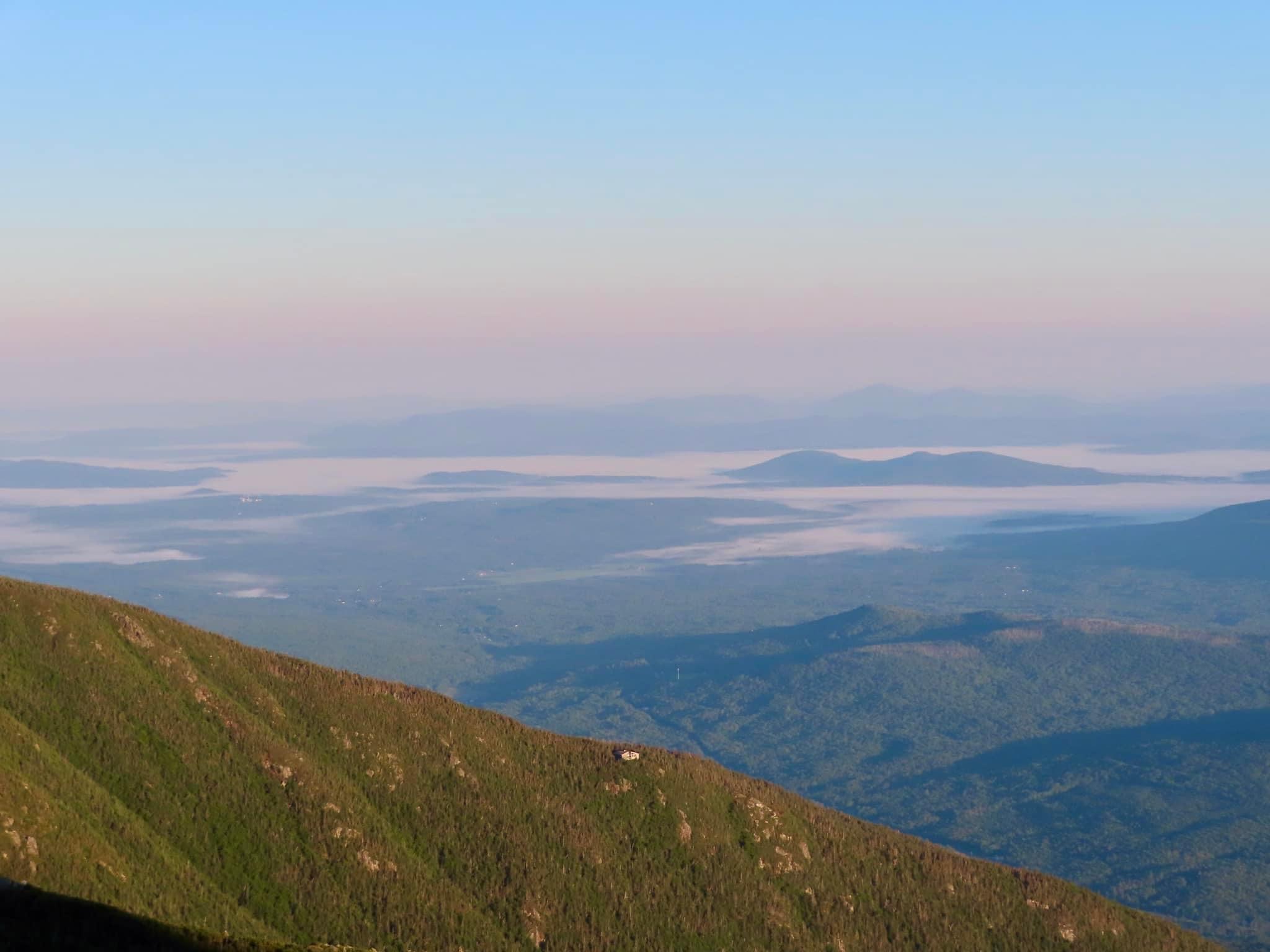
At 3:30 a.m. our alarm went off. In the pitch black, we made some instant coffee and packed up our tent and belongings as quietly as we could, trying not to disturb the other campers. Once everything was packed, we ate overnight oats on the way to the Appalachia Trailhead. There were already a couple of cars in the parking lot when we arrived. By 4:30 a.m. we hit the Valley Way trail with our headlamps. We started at a very brisk pace, the excitement and anticipation of such a big day fueling us to go faster. We came upon one other group who we passed and made quick talk about how perfect the temperature was and kept going upward. The colors started over the horizon just before we made it to Madison Spring Hut. Once at the hut, we checked to see if we wanted to top off our water bladders, but both were still pretty full. As we started up Mt. Madison, the sun started to appear over the horizon. Mt. Madison created a looming shadow over Madison Spring Hut below. Our first summit!


We always bring cash and a card with us when we are in the Presi’s because the AMC huts will often have baked goods, cold drinks, or other items that will just sound incredible when you’re hot, tired, and hungry. Be sure to fill your water up and use the restroom here if you need it because your next stretch without any amenities is a long and tough one, all the way to Washington. We quickly made our way back down to Madison Spring Hut and continued on to Adams. I really suffered here. Adams seems like a never-ending boulder field you navigate through until you reach the top. Once we summited, we pulled out our homemade sign that resembled the 4,000-footer patch and held it up while a nice fellow hiker took our photo. Our New Hampshire 48 4,000 footer list was COMPLETE!

But oh did we still have a long way to go. The greatest descent and gain is between Mt. Adams and Mt. Jefferson. You’ll find yourself saying “How much lower are we going to go” over and over until you reach the bottom.
Mount Jefferson is one of our favorite peaks! It has gorgeous views of the ridgeline looking toward Washington and Adams on the other side. We stopped here for some snacks and water before continuing on.


Next, you’ll traverse over a smaller summit, Mount Clay. After this smaller peak,
you’ll follow the Gulfside Trail until it meets the Cog Railway tracks, leading you to the summit of Mt. Washington! Just before reaching the cog, I ran out of water, so be sure to pack more than you think you’ll need to bridge this gap. Almost the entire hike is exposed, so on less windy days, the sun and heat can take a lot out of you. If you decide to veer off from the Gulfside Trail and continue following the cog tracks toward the summit, you can check out the Lizzie Bourne Monument Cairn. Lizzie Bourne passed in 1855 in an attempt to get to the summit. You can read more about her story inside the visitor center on the summit where they have a display about her story.
Once at the Observatory, be sure to use the restroom, refill your water(s), and grab a snack. Enjoy the gorgeous views and pose for a photo in front of the infamous summit sign.

You can get a clear picture of how far you’re going in one day from the summit. With views spanning from the beginning of your hike, Mount Madison, to the end, behind Eisenhower, you’ll be impressed. I ran into one guy checking out the views on the observatory deck and he asked, sounding very surprised, “did you hike up here?”. I told him yes and that we were half way through our presidential traverse, pointing out where we came from and where we were headed. He looked stunned and yelled to his friend “you wouldn’t believe what these two are doing!”. It gave us a good laugh before we headed into the building to enjoy the shade and a short break.
Be warned, if you sit down during your breaks, it is pretty hard to get yourself back up again to keep moving. By this point, our legs and feet were already starting to hurt. We enjoyed the long, leisurely descent to Lake of the Clouds hut, just below Mount Monroe. Once there, we again topped off our waters, enjoyed some chocolate-covered peanuts, and took a bathroom break. Then we put our packs back on and made the steep but short ascent up Mount Monroe.

After Monroe, you gradually make your way to Eisenhower, the most round mountain of them all! We didn’t stay there for long and kept on our way. Be weary of getting too close to the large cairn on Eisenhower, hornets and wasps are known to make a nest inside of it and they won’t be timid about making their presence known. It was at Eisenhower that we really started to hit a wall and wanted to be done with the day, but we still had some peaks left. Pierce, Jackson, and Webster. So on we trekked!

Pierce was beautiful and gave us an awesome vantage point of where we came from, but the summit was quite busy with other hikers. We took this quick photo (you can see I’m kind of over it lol) and kept going on our merry way to Jackson and Webster. Between Pierce and Eisenhower is the AMC Mizpah Hut. Here, you can have another break, fill your water, and enjoy snacks. But at this point, we kept going as fast as we could since our bodies were reaching their breaking point. Webster was extremely anticlimactic and felt like it took forever to reach. After a long time in the woods, you’ll stumble upon a small cairn surrounded by trees. We had some nice conversation and a good laugh with two other ladies who were determined to reach it and were also quite disappointed with the summit “views”.
The way down from Webster is steep and tough on the knees. I had started making noises with basically every movement I was in quite a lot of pain. After the long wooded descent, we popped out at the AMC Highland Center and saw my car waiting for us. It was a moment of teary-eyed joy. We enjoyed a beautiful sunset as we drove back up north to get Brad’s truck. It was a long two-hour drive home with throbbing legs and sleepy eyes, but we were proud of our accomplishment for the day. An epic 48 4,000 footer finish, and the longest day hike we’d ever done, all in one!
Leave a Reply